S.I. No. 285/1981 - Sea Fisheries (Conservation and Rational Exploitation) Order, 1981.
I, TOM FITZPATRICK, Minister for Fisheries and Forestry, in exercise of the powers conferred on me by sections 223A, 226 and 230 of the Fisheries (Consolidation) Act, 1959 (No. 14 of 1959), and the Fisheries (Transfer of Departmental Administration and Ministerial Functions) Order, 1977 ( S.I. No. 30 of 1977 ) (as adapted by the Fisheries (Alteration of Name of Department and Title of Minister) Order, 1978 ( S.I. No. 195 of 1978 )), hereby order as follows: | ||||||||
1. This Order may be cited as the Sea Fisheries (Conservation and Rational Exploitation) Order, 1981. | ||||||||
2. (1) In this Order— | ||||||||
“Annex 1” means Annex 1 to the Council Regulation; “the Council Regulation” means Council Regulation (EEC) No. 2527/80 of 30 September, 1980* ; | ||||||||
“ICES” refers to the International Council for the Exploration of the Sea. | ||||||||
(2) References in this Order to the Council Regulation shall be construed as references to that Regulation as continued in force, whether before or after the commencement of this Order, from time to time. | ||||||||
3. The provisions of the Council Regulation (being measures of conservation of fish stocks and rational exploitation of fisheries) in so far as they relate to the State, including the exclusive fisheries limits of the State, are hereby prescribed and adopted and accordingly any infringement of the Council Regulation within those limits (or, as the case may be, within the State) shall be an infringement of this Order. | ||||||||
4. In any proceedings in respect of a contravention of this Order which are proceedings in which an infringement of any provision of Title 1 of the Council Regulation is alleged, the onus shall be on the defendant to prove any defence which may be raised by him by virtue of Article 3 or 4 of the Council Regulation. | ||||||||
5. Where, in proceedings in which a contravention of this Order is alleged, it is proved by the prosecution that— | ||||||||
(a) fish were found on board a sea-fishing boat, | ||||||||
and | ||||||||
(b) at the time when the fish were so found the sea-fishing boat concerned was within both— | ||||||||
(i) the exclusive fishery limits of the State, and | ||||||||
(ii) any of the parts of the sea described in any of the paragraphs of the Table to Article 7 of this Order, | ||||||||
it shall be presumed until the contrary is proved by the defendant that all of the catch so found was taken within such limits and such part of the sea. | ||||||||
6. A net shall be measured for the purposes of this Order when wet with the mesh stretched diagonally length-wise of the net and a flat gauge 2 millimetres thick and of the appropriate width shall be used and in case a net is so measured its mesh shall not be regarded as being equal to or greater than the appropriate width unless such gauge passes easily through the mesh. | ||||||||
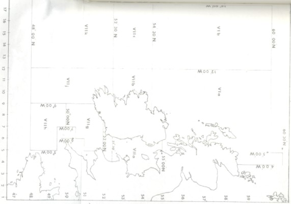
7. (1) The part of the sea referred to in the Council Regulation as the Celtic Sea is the part of the sea described in paragraph 1 of the Table to this Article. | ||||||||
(2) The parts of the sea which have been specified by the ICES and which are referred to in the second column of Annex 1 to the Council Regulation opposite the reference to Region 2 in the first column of that Annex (that is to say, (a) the part of the sea so referred to as west of Scotland, west of Ireland and western approaches and which is comprised of ICES divisions VIIb, VIIc, VIIg, VIIh, VIIj and VIIk, and ICES sub-area VI, and (b) the part of the sea so referred to as Irish Sea and which is comprised of ICES division VIIa) are those described in sub-paragraphs (a) and (b) respectively of paragraph 2 of the Table to this Article. | ||||||||
(3) The parts of the sea which have been specified by the ICES and which are referred to in the second column of Annex IV to the Council Regulation opposite the reference to Region 2 in the first column of that Annex (that is to say, (a) the part of the sea so referred to as west of Scotland, west of Ireland and which is comprised of ICES divisions VIa, VIIb, VIIc, VIIj and VIIk, and (b) the part of the sea so referred to as Irish Sea and western approaches and which is comprised of ICES divisions VIIa, VIIg, VIIh) are those described in sub-paragraphs (a) and (b) respectively, of paragraph 3 of the Table to this Article. | ||||||||
(4) The parts of the sea which are referred to in the third column of Annex VI to the Council Regulation opposite the reference to Region 2 in the second column of that Annex (that is to say, (a) the part of the sea so referred to as to west of Scotland, Irish Sea and west of Ireland and which is comprised of ICES divisions VIa, VIIa, VIIb, VIIc, VIIj and VIIk, and (b) the part of the sea so referred to as western approaches and which is comprised of the ICES divisions, VIIg and VIIh) are those described in sub-paragraphs (a) and (b) respectively, of paragraph 4 of the Table to this Article. | ||||||||
|
TABLE | ||||||||
1. (a) That part of the sea other than the part described in subparagraph (b) which is enclosed by an imaginary line drawn from the point on the high-water mark on the Wexford coast at 52°30’ north latitude true east along that latitude to the point at which it meets the high-water mark on the Welsh coast and thence along the high-water mark on the Welsh coast, initially in a southerly direction, to the most southerly point at which the meridian of 5° west longitude meets the high-water mark on that coast, thence true south along that longitude to latitude 51° north, thence true west along the last-mentioned latitude to longitude 6° west, thence true south along the last-mentioned longitude to latitude 50°30’ north, thence true west along the last-mentioned latitude to longitude 7° west, thence true south along the last-mentioned longitude to latitude 49°30’ north, thence true east along the last-mentioned latitude to longitude 5° west, thence true south along the last-mentioned longitude to latitude 48° north, thence true west along the last-mentioned latitude to longitude 18° west, thence true north along the last-mentioned longitude to latitude 52°30’ north thence true east along the last-mentioned latitude to the high-water mark on the Kerry coast, thence along the Irish Coast, initially in a southerly direction to the point first-mentioned. | ||||||||
(b) The part of the sea which forms the part of the exclusive fishery limits of the State lying landward of a line drawn six nautical miles seaward of the baseline that lies west of longitude 9° west and south of latitude 52°30’ north. | ||||||||
2. (a) That part of the sea which is enclosed by an imaginary line drawn from the point on the high-water mark on the Waterford coast at 52° north latitude true east along that latitude to the point at which it meets the high-water mark on the Welsh coast and thence along the high-water mark of the Welsh coast initially in a south-easterly direction, to the most southerly point at which the meridian of 5° west longitude meets the high-water mark on that coast, thence true south along that longitude to latitude 51° north thence true west along the last-mentioned latitude to longitude 6° west thence true south along the last-mentioned longitude to latitude 50°30’ north, thence true west along the last mentioned latitude to longitude 7° west, thence true south along the last mentioned longitude to latitude 49°30’ north thence true east along the last-mentioned latitude to longitude 5° west, thence true south along the last-mentioned longitude to latitude 48° north thence true west along the last-mentioned latitude to longitude 18° west, thence true north along the last mentioned longitude to latitude 60° north, thence true east along the last-mentioned latitude to longitude 5° west, thence true north along the last-mentioned longitude to latitude 60°30’ north, thence true east along the last-mentioned latitude to longitude 4° west, thence true south along the last-mentioned longitude to the point at which it meets the high-water mark on the Scottish coast, thence along the high-water mark of the Scottish coast to the point on the high-water mark at 55° north latitude, thence true west along the last-mentioned latitude to the point at which it meets the high-water mark on the Antrim Coast, thence along the Irish coast, initially in a northerly direction, to the point first-mentioned. | ||||||||
(b) That part of the sea which is enclosed by an imaginary line drawn from the point on the high-water mark on the Waterford coast at 52°00’ north latitude true east along that latitude to the point at which it meets the high water mark on the Welsh coast and thence along the high-water mark of the Welsh, English and Scottish coasts, via the Menai Strait, to the point on the high-water mark at 55°00’ north latitude, thence true west along the last-mentioned latitude to the point at which it meets the high-water mark on the Antrim coast, thence along the Irish coast, initially in a south-easterly direction, to the point first-mentioned. | ||||||||
3. (a) That part of the sea which is enclosed by an imaginary line drawn from the point on the high-water mark on the Cork coast at 9° west longitude true south along that longitude to the point at which it meets latitude 48° north, thence true west along that latitude to the point at which it meets longitude 18° west, thence true north along the last-mentioned longitude to the point at which it meets latitude 54°30’ north, thence true east along the last-mentioned latitude to the point at which it meets longitude 12° west, thence true north along the last mentioned longitude to the point at which it meets latitude 60° north, thence true east along the last-mentioned latitude to longitude 5° west, thence true north along the last-mentioned longitude to latitude 60°30’ north, thence true east along the last-mentioned latitude to longitude 4° west, thence true south along the last-mentioned longitude to the point at which it meets the high-water mark on the Scottish coast, thence along the high-water mark on the Scottish coast to the point on the high-water mark on that coast at 55° north latitude, thence true west along the last-mentioned latitude to the point at which it meets the high-water mark on the Antrim coast, thence along the Irish coast, initially in a northerly direction, to the point first-mentioned. | ||||||||
(b) That part of the sea which is enclosed by an imaginary line drawn from the point on the high-water mark on the Antrim coast at 55° north latitude true east along that latitude to the point where it meets the high-water mark on the Scottish coast and thence along the high-water mark on the Scottish, English and Welsh coasts, via the Menai Strait to the most southerly point at which the meridian of 5° west longitude meets the high-water mark on the Welsh coast, thence true south along that longitude to latitude 51° north, thence true west along the last-mentioned latitude to longitude 6° west, thence true south along the last-mentioned longitude to latitude 50° 30’ north, thence true west along the last-mentioned latitude to longitude 7° west, thence true south along the last-mentioned longitude to latitude 49° 30’ north, thence true east along the last-mentioned latitude to longitude 5°west, thence true south along the last-mentioned longitude to latitude 48° north, thence true west along the last-mentioned latitude to longitude 9° west thence true north along the last-mentioned longitude to the point where it meets the high-water mark on the Cork coast, thence along the Irish coast, initially in an easterly direction, to the point first-mentioned. | ||||||||
4. (a) That part of the sea which is enclosed by an imaginary line drawn from the point on the high-water mark on the Cork coast at 9° west longitude true south along that longitude to the point at which it meets latitude 48° north, thence true west along that latitude to the point at which it meets longitude 18° west, thence true north along the last-mentioned longitude to the point at which it meets latitude 54°30’ north, thence true east along the last-mentioned latitude to the point at which it meets longitude 12° west, thence true north along the last mentioned longitude to the point at which it meets latitude 60° north, thence true east along the last-mentioned latitude to longitude 5° west, thence true north along the last-mentioned longitude to latitude 60°30’ north, thence true east along the last-mentioned latitude to longitude 4° west, thence true south along the last-mentioned longitude to the point at which it meets the high-water mark on the Scottish coast, thence along the high-water mark of the Scottish coast to the point on the high-water mark on that coast at 55° north latitude, thence along the Scottish, English and Welsh coasts, via the Menai Strait to the point on the high-water mark at 52° north latitude, thence true west along the last-mentioned latitude to the point at which it meets the high-water mark on the Waterford coast thence along the Irish coast, initially in a southerly direction, to the point first-mentioned. | ||||||||
(b) That part of the sea which is enclosed by an imaginary line drawn from the point on the high-water mark on the Waterford coast at 52° north latitude true east along that latitude to the point at which it meets the high-water mark on the Welsh coast and thence along the high-water mark on the Welsh coast, initially in a south-easterly direction to the most southerly point at which the meridian of 5° west longitude meets the high-water mark on that coast, thence true south along that longitude to latitude 51° north thence true west along the last-mentioned latitude to longitude 6° west, thence true south along the last-mentioned longitude to latitude 50°30’ north, thence true west along the last-mentioned latitude to longitude 7° west, thence true south along the last-mentioned longitude to latitude 49°30’ north, thence true east along the last-mentioned latitude to longitude 5°west, thence true south along the last-mentioned longitude to latitude 48° north, thence true west along the last-mentioned latitude to longitude 9° west, thence true north along the last-mentioned longitude to the point at which it meets the high-water mark on the Cork coast, thence along the Irish coast, initially in an easterly direction, to the point first-mentioned. | ||||||||
8. Where in any paragraph of the Table to Article 7 of this Order an imaginary line is expressed to proceed from a particular point initially in a particular direction, reference shall be made to the map contained in the Schedule to this Order for the purpose of determining the general direction in which such line so proceeds. | ||||||||
9. The following are hereby revoked: | ||||||||
(a) Purse Seine Prohibition Order, 1971 ( S.I. No. 262 of 1971 ); | ||||||||
(b) Herring (Prohibition of Fishing) Order, 1976 ( S.I. No. 170 of 1976 ); | ||||||||
(c) Article 5 of the Sea Fisheries (Conservation and Rational Exploitation) (No. 2) Order, 1978 ( S.I. No. 163 of 1978 ); | ||||||||
(d) Sea Fisheries (Cónservation and Rational Exploitation) (No. 5) Order, 1978 ( S.I. No. 243 of 1978 ); | ||||||||
(e) Fishing Nets (Regulation of Mesh) Order, 1978 ( S.I. No. 244 of 1978 ); | ||||||||
(f) Article 5 (1) of the Sea Fisheries (Conservation and Rational Exploitation) (No. 2) Order, 1979 ( S.I. No. 420 of 1979 ); | ||||||||
(g) Undersized Sea Fish Order, 1980, ( S.I. No. 341 of 1980 ). | ||||||||
| ||||||||
|
EXPLANATORY NOTE. | ||||||||
(This note is not part of the Instrument and does not purport to be a legal interpretation.) | ||||||||
This Order makes any infringement of Council Regulation (EEC) No. 2527/80, which prescribes certain technical measures for the conservation of fishery resources, an offence in so far as that Regulation relates to the State. | ||||||||
|
SCHEDULE. | ||||||||
| ||||||||