S.I. No. 362/1994 - Urban Renewal Act, 1986 (Designated Areas) (Cork) Order, 1994.
S.I. No. 362 of 1994. | ||
URBAN RENEWAL ACT, 1986 (DESIGNATED AREAS) (CORK) ORDER, 1994. | ||
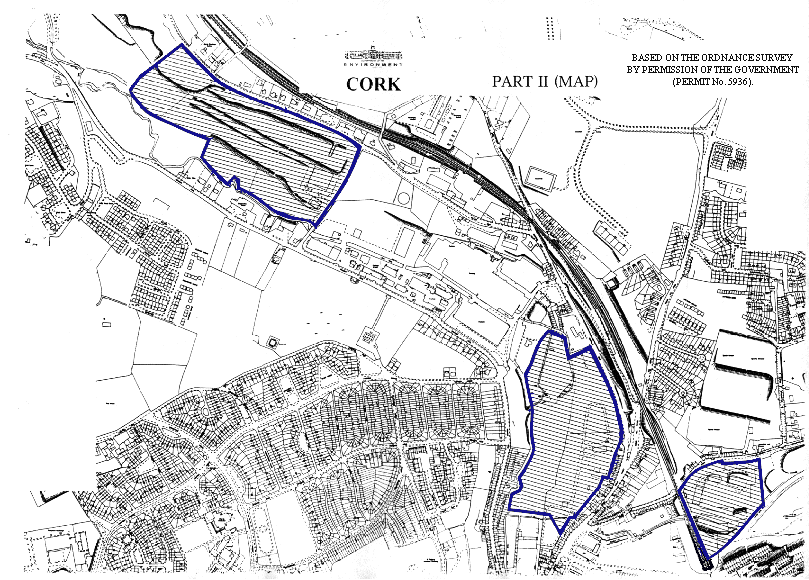
The Minister for the Environment in exercise of the powers conferred on him by section 6 (2) of the Urban Renewal Act, 1986 (No. 19 of 1986) hereby orders as follows: 1. This Order may be cited as the Urban Renewal Act, 1986 (Designated Areas) (Cork) Order, 1994. 2. Each of the areas described in Part II of the Schedule to this Order is hereby declared to be a designated area for the purposes of the Urban Renewal Act, 1986 . 3. Each of the streets or parts of those streets described in Part III of the Schedule to this Order is hereby declared to be a designated area for the purposes of the Urban Renewal Act, 1986 . 4. Each of the hatched areas enclosed by blue lines on the map on the sheet entitled Cork Part II (Map) attached hereto is hereby declared to be a designated area for the purposes of the Urban Renewal Act, 1986 . | ||
|
SCHEDULE | ||
PART I | ||
In this Schedule— | ||
"thoroughfare" includes any avenue, bridge, channel, cottages, hill, lane, parade, place, quay, row, steps, street, and wall; | ||
a reference to a line drawn along any thoroughfare is a reference to a line drawn along the centre of that thoroughfare; | ||
a reference to a projection of any thoroughfare is a reference to a projection of a line drawn along the centre of that thoroughfare; | ||
a reference to the point where any thoroughfare or projection of any thoroughfare intersects or joins any other thoroughfare or projection of a thoroughfare is a reference to the point where a line drawn along the centre of one thoroughfare, or in the case of a projection of a thoroughfare, along the projection, would be intersected or joined by a line drawn along the centre of the other thoroughfare or, in the case of another projection of a thoroughfare, along the other projection; | ||
a reference to a point where any thoroughfare is intersected by the projection of a boundary is a reference to the point where a line drawn along the centre of such thoroughfare would be intersected by the projection of such boundary. | ||
PART II | ||
South Gate Area | ||
That part of the county borough of Cork bounded by a line commencing at the point (hereafter in this description referred to as the first-mentioned point) where South Main Street is joined by Hanover Street, thence in a southerly direction along South Main Street to the point where it is joined by Kifts Lane, then continuing in an easterly direction along Kifts Lane to the point where it joins Grand Parade then continuing in a southerly direction along Grand Parade and the southerly projection thereof to the point where it intersects Sullivan's Quay, then continuing in a westerly direction along Sullivan's Quay to the point where it joins Barrack Street, then continuing in southerly direction along Barrack Street to the point where it is joined by Cove Street, then continuing in an easterly direction along Cove Street to the point where it is joined by Nicholas Church Lane, then continuing in a southerly direction along Nicholas Church Lane to the point where it joins Evergreen Street, then continuing in a north-westerly direction along Evergreen Street to the point where it joins Barrack Street, then continuing in a south-westerly direction along Barrack Street to the point where it is joined by Keysers Hill, then continuing initially in a north-westerly and then in a northerly direction along Keysers Hill and the northerly projection thereof to the point where it intersects the South Channel of the River Lee, then continuing, initially in a north-westerly direction, along the said South Channel to the point where it is intersected by Clark's Bridge, then continuing in a northerly direction along Clark's Bridge and Wandesford Street to the point where it joins Hanover Street, then continuing in an easterly direction along Hanover Street to the first-mentioned point. | ||
North Gate Area | ||
That part of the country borough of Cork bounded by a line commencing at the point (hereafter in this description referred to as the first-mentioned point) where St. Vincent's Bridge is intersected by the North Channel of the River Lee, thence in a southerly direction along St. Vincent's Bridge to the point where it meets Grenville Place, then continuing in an easterly direction along Grenville Place to the point where it joins Millerd Street, then continuing in a southerly direction along Millerd Street and Moore Street to the point where it joins Sheares Street, then continuing in a south-easterly direction along Sheares Street to the point where it is joined by Coach Street, then continuing in a northerly direction along Coach Street to the point where it joins Henry Street, then continuing in a north-easterly direction along Henry Street to the point where it joins Grattan Street, then continuing in a southerly direction along Grattan Street to the point where it is joined by St. Peter's Avenue, then continuing in an easterly direction along St. Peter's Avenue to the point where it joins North Main Street, then continuing in a northerly direction along North Main Street to the point where it joins Bachelor's Quay, then continuing in a westerly direction along Bachelor's Quay to the point where it is intersected by the southerly projection of Mans Lane, then continuing in a northerly direction along that projection and Mans Lane to the point where it joins Rock Cottages, then continuing in an easterly direction along Rock Cottages to the point where it is joined by Rock Steps, then continuing in a northerly direction along Rock Steps to the point where it is joined by the base of the escarpment, then continuing in a westerly direction along the base of the escarpment to its end, then continuing due south in an undefined straight line to the point where it intersects Sunday's Well Road, then continuing in a south-easterly direction along Sunday's Well Road to the point where it meets the northerly projection of St. Vincent's Bridge, then continuing in a southerly direction along the last-mentioned projection and St. Vincent's Bridge to the first-mentioned point. | ||
MacCurtain Street Area | ||
That part of the county borough of Cork bounded by a line commencing at the point (hereafter in this description referred to as the first-mentioned point) where St. Patrick's Quay meets Bridge Street, thence in a northerly direction along Bridge Street and St. Patrick's Hill to the point where it is joined by St. Patrick's Place, then continuing in an easterly direction along St. Patrick's Place and Wellington Road to the point where it joins York Street, then continuing in a southerly direction along York Street to the point where it joins MacCurtain Street, then continuing in a westerly direction along MacCurtain Street to the point where it is joined by Harley's Street, then continuing in a southerly direction along Harley's Street to the point where it joins St. Patrick's Quay, then continuing in a westerly direction along St. Patrick's quay to the first-mentioned point. | ||
Blackpool Area | ||
That part of the county borough of Cork bounded by a line commencing at the point (hereafter in this description referred to as the first-mentioned point) where Pope's Road meets Watercourse Road, then continuing in a northerly direction along Watercourse Road to the point where Watercourse Road, Thomas Davis Street and Blackpool Bridge meet, then continuing in a westerly direction along Blackpool Bridge to the point where it is intersected by the River Bride, then continuing in a north westward direction along the River Bride to the point where it meets the channel linking the River Bride to Back Water Course, then continuing in an eastward direction along that linking channel for 100 metres, then continuing in an undefined straight line south-eastward to a point at the junction of Glen Avenue and Thomas Davis Street, then continuing north eastward along Thomas Davis Street and Dublin Street to the point where it is intersected by the north-westerly projection of the south-western boundary of No. 29 Dublin Street, then continuing in a south easterly direction along that projection and boundary and the south easterly projection thereof to the point where it intersects the aforementioned linking channel, then continuing, initially in a south easterly direction, along this linking channel to its junction with the Back Water Course, then continuing along an imaginary straight line from this point to the northernmost point of No. 31 Farran Cleary Place, then continuing in a southerly direction along the boundary of the last-mentioned premises to the point where it meets the northern boundary of the Convent of Assumption, then continuing in an easterly direction along the last-mentioned boundary to the point where it meets the eastern boundary of the Convent of Assumption, then continuing in a southerly direction along the last-mentioned boundary and the southerly projection thereof to the point where it intersects Assumption Road, then continuing in a westerly direction along Assumption Road for a distance of 20 metres, then continuing in a southerly direction in an undefined straight line to the north east corner of Old Watercourse Road Distillery, then continuing in a southerly direction along the eastern boundary of the last-mentioned premises to the point where it joins Pope's Road, then continuing due south eastward in a straight line to the centre of Pope's Road, then continuing, initially in a southerly direction along Pope's Road to the first-mentioned point. | ||
PART III | ||
The following streets or parts of streets in the county borough of Cork which are not part of any area declared to be a designated area under articles 2 or 4 of this Order | ||
(i) Barrack Street, | ||
(ii) South Main Street, | ||
(iii) Castle Street, | ||
(iv) North Main Street, | ||
(v) Shandon Street, | ||
(vi) Gerald Griffin Street, | ||
(vii) Great William O'Brien Street. | ||
GIVEN under the Official Seal of the Minister for the Environment, | ||
this 30th day of November, 1994. | ||
MICHAEL SMITH, | ||
Minister for the Environment. | ||
The Minister for Finance hereby consents to this Order. | ||
GIVEN under the Official Seal of the Minister for Finance, this | ||
30th day of November, 1994. | ||
BERTIE AHERN, | ||
Minister for Finance. | ||
EXPLANATORY NOTE. | ||
This Order provides for the designation of areas in Cork under the Urban Renewal Act, 1986 . | ||
|
CORK PART II (MAP) | ||
|