S.I. No. 806/2007 - Irish Aviation Authority (Designated Areas) Order, 2007
Notice of the making of this Statutory Instrument was published in | |||||||||||||||||||||||
“Iris Oifigiúil” of 14th December, 2007. | |||||||||||||||||||||||
The Irish Aviation Authority in pursuance of the powers conferred by Section 5 and 68 (1) of the Irish Aviation Authority Act 1993 , Number 29 of 1993, with the consent of the Minister for Transport and the Minister for Defence, hereby orders the designation of the areas of Irish Airspace in Articles 4 and 5 hereunder for use by the Defence Forces. | |||||||||||||||||||||||
1. This order may be cited as the Irish Aviation Authority (Designated Areas) Order, 2007. | |||||||||||||||||||||||
2. This order shall come into operation at 00:01 hours on the 13th day of March, 2008. | |||||||||||||||||||||||
3. In this Order: | |||||||||||||||||||||||
“the Act” means the Irish Aviation Authority Act, 1993 (No. 29 of 1993) as amended; | |||||||||||||||||||||||
“designated area” (as specified in section 68 of the Act) means an airspace of defined dimensions designated by the Irish Aviation Authority with the consent of the Minister for Transport and the Minister for Defence for use by the Defence Forces. An aircraft, other than an aircraft of the Defence Forces, may not enter such an airspace without the permission of the person operating air navigation services therein; | |||||||||||||||||||||||
“restricted area” means, for the purposes of this Order, airspace of defined dimensions in a designated area above the land areas or territorial waters of the state, within which the flight of civil aircraft is subject to specified restrictions; | |||||||||||||||||||||||
“TOP” Maximum vertical extent (expressed as an altitude or level) of an area of airspace; | |||||||||||||||||||||||
“BASE” Minimum vertical extent (expressed as the surface, an altitude or level) of an area of airspace; | |||||||||||||||||||||||
“AREA database” A name attributed to a collection of data defining the boundaries of the airspace areas referred to in this Order, listed in Part I of the Schedule to the Order and described in the database interpretative material contained in Part II of the Schedule to the Order; | |||||||||||||||||||||||
“EIR...” means, for purposes of this Order, a restricted area, within a designated area, individually identified by a number and the boundary of which is defined by co-ordinates and data in the AREA database as specified in Part 1 of the Schedule to the Order and as depicted, by way of illustration only, on the map in Part III of the Schedule; | |||||||||||||||||||||||
“MOA...” means, for purposes of this Order, a restricted area, termed a military operational area, within a designated area, individually identified by a number and the boundary of which is defined by co-ordinates and data specified in Part 1 of the Schedule to the Order and as depicted, by way of illustration only, on the map in Part III of the Schedule; | |||||||||||||||||||||||
“military operational area” means, for the purposes of this Order, a restricted area for use by aircraft of the Defence Forces within which the flight of civil aircraft may be restricted in accordance with such standing criteria as are specified by the Authority in relation thereto and published in the Aeronautical Information publication. | |||||||||||||||||||||||
4. The areas EIR 15, EIR 16, EIR 22, EIR 23 are hereby designated as restricted areas with vertical and lateral extent as defined for each area by the AREA database and database interpretative material in Parts I and II of the Schedule to the Order as follows: | |||||||||||||||||||||||
— the lateral extent within the area boundaries is defined in the AREA database, for each area as appropriate, by one or more of the following: | |||||||||||||||||||||||
a:— | |||||||||||||||||||||||
— Point Sequence, | |||||||||||||||||||||||
— Point Name/Description, | |||||||||||||||||||||||
— Latitude, | |||||||||||||||||||||||
— Longitude, | |||||||||||||||||||||||
— Line Type, | |||||||||||||||||||||||
— Centre Latitude, | |||||||||||||||||||||||
— Centre Longitude, and | |||||||||||||||||||||||
— Radius (NM). | |||||||||||||||||||||||
— the vertical extent is defined from BASE up to and including TOP for each area by data elements in the AREA database. | |||||||||||||||||||||||
5. The following airspace areas MOA 3, MOA 4, MOA 5 are hereby designated as military operational areas with vertical and lateral extent as defined for each area by the AREA database and database interpretative material in Parts I and II of the Schedule to the Order, as follows: | |||||||||||||||||||||||
— the lateral extent within the area boundaries is defined in the AREA database, for each area as appropriate, by one or more of the following: | |||||||||||||||||||||||
a: | |||||||||||||||||||||||
— Point Sequence, | |||||||||||||||||||||||
— Point Name/Description, | |||||||||||||||||||||||
— Latitude, | |||||||||||||||||||||||
— Longitude, | |||||||||||||||||||||||
— Line Type, | |||||||||||||||||||||||
— Centre Latitude, | |||||||||||||||||||||||
— Centre Longitude, and | |||||||||||||||||||||||
— Radius (NM). | |||||||||||||||||||||||
— the vertical extent of each area is defined from BASE up to and including TOP for each area by data elements in the AREA database. | |||||||||||||||||||||||
6. The Air Navigation (Designated Areas) Order, 2002 ( S.I. No. 140 of 2002 ) is hereby revoked. | |||||||||||||||||||||||
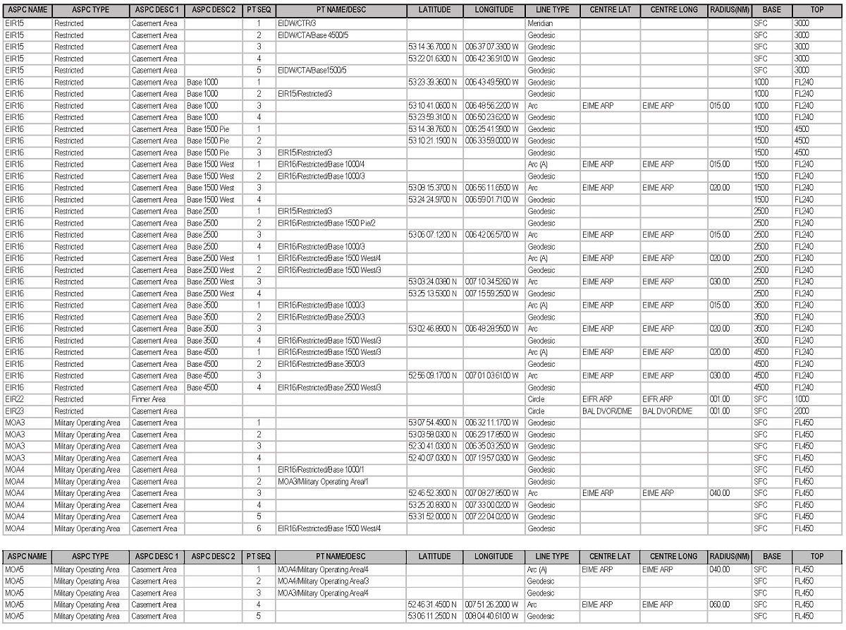
SCHEDULE AREA DATABASE AND DATABASE INTERPRETATIVE MATERIAL | |||||||||||||||||||||||
Part 1 | |||||||||||||||||||||||
AREA DATABASE | |||||||||||||||||||||||
| |||||||||||||||||||||||
Part II | |||||||||||||||||||||||
AREA DATABASE INTERPRETATIVE MATERIAL | |||||||||||||||||||||||
AREA Database Description: | |||||||||||||||||||||||
The AREA database contains a listing of data defining the boundaries of the Irish Airspace Organisation components. | |||||||||||||||||||||||
AREA Database Structure: | |||||||||||||||||||||||
1. (a) The database contains blocks of airspace. Each block is identified uniquely using the column identifiers ASPC NAME, ASPC TYPE, ASPC DESC 1 and ASPC DESC 2. | |||||||||||||||||||||||
(b) The boundaries of each block are defined by a sequence of points, one at each apex, joined by a specific line type. | |||||||||||||||||||||||
(c) Each record contains the point name/description or geographic co-ordinates, representing the sequence point, together with the line type joining that point to the subsequent sequence point contained in the following record. | |||||||||||||||||||||||
(d) The final sequence point for each block is joined to the first sequence point. | |||||||||||||||||||||||
(e) Where a line type ARC or Circle is given, then data representing the centre and radius are included in the record. | |||||||||||||||||||||||
(f) Where a record contains a point common to another record within the database, such point is identified in the field under the column identifier “PT NAME/DESC” by reference to the appropriate field entries of the common point’s record, separated by a forward slash. This ensures that co-ordinates of a point are not entered into the database more than once. | |||||||||||||||||||||||
2. All geographic co-ordinates are those of the World Geodetic System, 1984 (WGS-84). | |||||||||||||||||||||||
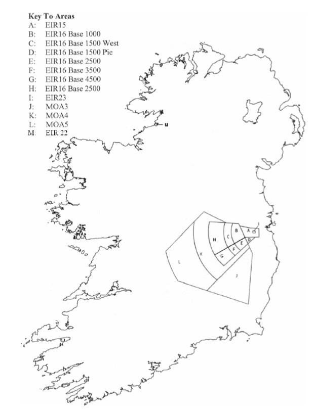
3. A map is attached, for illustrative purposes only, showing Designated Airspace and depicting a plan of the Restricted Areas and Military Operational Areas identified by ASPC NAME and ASPC DESC 2 in the AREA database. | |||||||||||||||||||||||
AREA Database Listing of Column Identifiers | |||||||||||||||||||||||
The listing of data in the AREA database contains the following column identifier abbreviations: | |||||||||||||||||||||||
| |||||||||||||||||||||||
AREA Database Data Element Abbreviation Description | |||||||||||||||||||||||
(1) Line Type | |||||||||||||||||||||||
| |||||||||||||||||||||||
(2) Other Elements | |||||||||||||||||||||||
Abbreviations for other data elements within the AREA database include the following descriptions: | |||||||||||||||||||||||
| |||||||||||||||||||||||
Data Element Values | |||||||||||||||||||||||
Values for data elements within the AREA Database include the following: | |||||||||||||||||||||||
| |||||||||||||||||||||||
Part III | |||||||||||||||||||||||
MAP | |||||||||||||||||||||||
Part III — MAP (For illustrative purposes) | |||||||||||||||||||||||
| |||||||||||||||||||||||
| |||||||||||||||||||||||
GIVEN under the common seal of the Irish Aviation Authority, | |||||||||||||||||||||||
12 December 2007 | |||||||||||||||||||||||
FRANK COWNWAY. | |||||||||||||||||||||||
Director | |||||||||||||||||||||||
Present when the common seal of the Irish Aviation Authority was affixed hereto. | |||||||||||||||||||||||
| |||||||||||||||||||||||
GIVEN under the common seal of the Irish Aviation Authority, | |||||||||||||||||||||||
12 December 2007 | |||||||||||||||||||||||
DONAL DOWNING. | |||||||||||||||||||||||
Director | |||||||||||||||||||||||
EXPLANATORY NOTE | |||||||||||||||||||||||
(This note is not part of the Order and does not purport to be a legal interpretation). | |||||||||||||||||||||||
1. This Order relates to the designation of certain amended areas of airspace for use by theDefence Forces. | |||||||||||||||||||||||
2. This Order revokes and re-enacts with modifications and additions the Irish Aviation Authority (Designated Areas) Order, 2002 ( S.I. No. 140 of 2002 ). | |||||||||||||||||||||||
3. This Order provides for: | |||||||||||||||||||||||
— an amendment to the lateral and vertical limits of the existing Restricted Area EIR 16 (to accommodate revised flight procedures for Operational Air Traffic at Casement Aerodrome Co. Dublin and revised Civil/Military Air Traffic Control Coordination procedures); | |||||||||||||||||||||||
— prescribing lateral limits for all designated areas based on co-ordinates in the World Geodetic System of 1984. |