| |
S.I. No. 173 of 1959.
|
| |
MARITIME JURISDICTION ACT, 1959 (STRAIGHT BASELINES) ORDER, 1959.
|
| |
The Government, in exercise of the power conferred on them by subsection (2) of
section 4
of the
Maritime Jurisdiction Act, 1959
(No. 22 of 1959), hereby order as follows :
1. This Order may be cited as the
Maritime Jurisdiction Act, 1959
(Straight Baselines) Order, 1959.
2. This Order shall come into operation on the 1st day of January, 1960.
3. Straight lines joining in succession the points the co-ordinates of which are given in a particular Part of the Schedule shall be straight baselines for the purposes of the
Maritime Jurisdiction Act, 1959
.
|
| |
SCHEDULE.
|
| |
TERMINAL POINTS OF STRAIGHT BASELINES.
|
| | |
Reference Number
|
Co-ordinates of Points
|
Location
|
|
North Latitude
|
West Longtitude
|
|
Part A.
|
|
1.
|
55°22·6'
|
7°24·2'
|
Scart Rocks, Malin Head
|
|
2.
|
55°15·4'
|
7°47·1'
|
Melmore Head
|
|
3.
|
55°13·7'
|
7°58·9'
|
Horn Head
|
|
4.
|
55°12·4'
|
8°09·5'
|
Inishbeg
|
|
5.
|
55°09·6'
|
8°17·0'
|
Bloody Foreland
|
|
6.
|
55°04·5'
|
8°28·9'
|
Stag Rocks
|
|
7.
|
55°00·8'
|
8°33·8'
|
Rinrawros Point, Aran Island
|
|
8.
|
54° 42·0'
|
8° 48·2'
|
Malinmore Head
|
|
| | |
Reference Number
|
Co-ordinates of Points
|
Location
|
|
North Latitude
|
West Longtitude
|
|
Part B.
|
|
9.
|
54°39·6'
|
8°47·3'
|
West entrance to Malinbeg Bay
|
|
10.
|
54°17·8'
|
9°03·3'
|
Lenadoon Point
|
|
11.
|
54°19·7'
|
9°20·5'
|
Downpatrick Head
|
|
Part C.
|
|
12.
|
54°19·8'
|
9°51·9'
|
Kid Island, Broadhaven
|
|
13.
|
54°18·6'
|
9°59·9'
|
Rocky Island, Erris Head
|
|
14.
|
54°16·9'
|
10°05·6'
|
Eagle Island
|
|
15.
|
54°03·7'
|
10°21·0'
|
Blacksod Bay (Rock to S.W. of Black Rock)
|
|
16.
|
53°58·3'
|
10°16·5'
|
Carrickakin, Achill Island
|
|
17.
|
53°36·3'
|
10°19·2'
|
Kemmeen Rocks, Inishark
|
|
18.
|
53°24·0'
|
10°14·5'
|
Slyne Head
|
|
19.
|
53°08·8'
|
9°51·6'
|
Eeragh Island, Aran Islands
|
|
20.
|
53°08·4'
|
9°50·9'
|
South Island, Aran Islands
|
|
Part D.
|
|
21.
|
53°05·2'
|
9°38·5'
|
S.E. corner Inishmore, Aran Islands
|
|
22.
|
53°03·9'
|
9°37·0'
|
Inishmaan, Aran Islands
|
|
23.
|
53°02·8'
|
9°33·3'
|
Inisheer, Aran Islands
|
|
24.
|
52°56·4'
|
9°28·5'
|
Cregga More
|
|
25.
|
52°43·8'
|
9°38·2'
|
Donegal Point
|
|
Part E.
|
|
26.
|
52°33·6'
|
9°56·3'
|
Loop Head
|
|
27.
|
52°25·2'
|
9°56·8'
|
Kerry Head
|
|
28.
|
52°17·6'
|
10°10·4'
|
Deelick Point
|
|
Part F.
|
|
29.
|
52°10·9'
|
10°28·4'
|
Sybil Point
|
|
30.
|
52°08·3'
|
10°34·5'
|
Inishtooskert, Blasket Islands
|
|
31.
|
52°07·7'
|
10°35·7'
|
Carrigduff, Blasket Islands
|
|
32.
|
52°04·6'
|
10°41·0'
|
Tearaght Rocks West, Inistearaght
|
|
33.
|
52°01·3'
|
10°41·3'
|
Great Foze Rock
|
|
34.
|
51° 45·8'
|
10° 32·7'
|
Washerwoman Rock, Great Skellig
|
|
| | |
Reference Number
|
Co-ordinates of Points
|
Location
|
|
North Latitude
|
West Latitude
|
|
35.
|
51°35·5'
|
10°18·5'
|
Gull Rock, Dursey Island
|
|
36.
|
51°34·2'
|
10°14·8'
|
Calf Rock, Dursey Island
|
|
37.
|
51°26·9'
|
9°49·2'
|
Mizen Head
|
|
38.
|
51°25·2'
|
9°30·8'
|
Bream Point, Cape Clear
|
|
39.
|
51°28·0'
|
9°13·4'
|
The Stags, Toe Head
|
|
40.
|
51°31·8'
|
8°57·2'
|
Galley Head
|
|
41.
|
51°34·2'
|
8°42·7'
|
Seven Heads
|
|
42.
|
51°36·3'
|
8°32·0'
|
Old Head of Kinsale
|
|
43.
|
51°49·5'
|
7°59·0'
|
Ballycotton Island
|
|
44.
|
51°52·9'
|
7°51·2'
|
Capel Island, Knockadoon Head
|
|
45.
|
51°56·5'
|
7°42·4'
|
Ram Head
|
|
46.
|
51°59·6'
|
7°34·6'
|
The Rogue, Mine Head
|
|
47.
|
52°07·4'
|
6°55·7'
|
Hook Head
|
|
48.
|
52°06·5'
|
6°37·4'
|
Great Saltee Island (Souther most Point)
|
|
49.
|
52°09·2'
|
6°24·6'
|
Black Rock, Carnsore
|
|
50.
|
52° 10·3'
|
6° 21·8'
|
Carnsore Point
|
|
| |
GIVEN under the Official Seal of the Government, this 20th day of October, 1959.
|
| |
SEÁN F. LEMASS,
|
| |
Taoiseach.
|
| |
EXPLANATORY NOTE.
|
| |
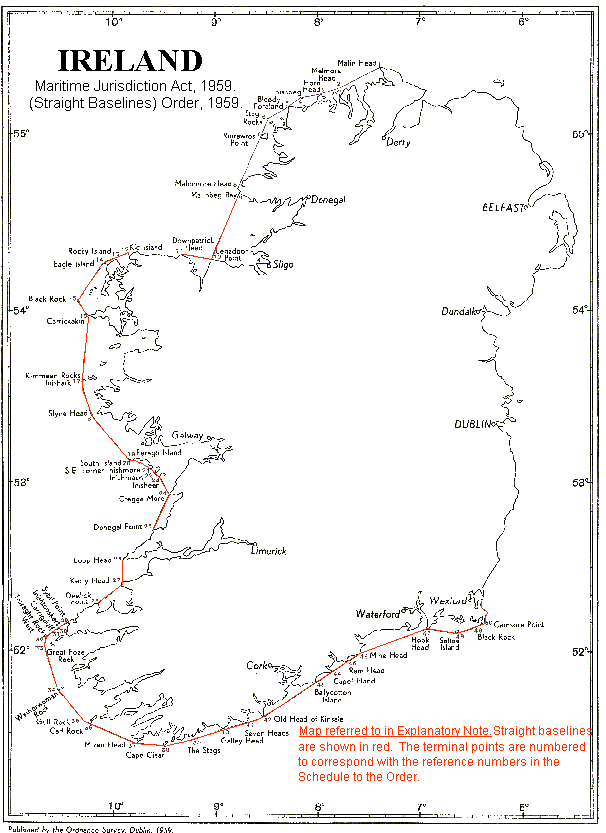
The Order prescribes straight baselines from which the territorial seas are to be measured in relation to certain parts of the national territory.
|
| |
A map showing the prescribed straight baselines is annexed.
|
| |
Maritime Jurisdiction Act, 1959
. (Straight Baselines) Order, 1959.
|
| |
|