| |
Notice of the making of this Statutory Instrument was published in
|
| |
“Iris Oifigiúil” of 19th January, 2016.
|
| |
The Government, in exercise of the powers conferred on them by
section 85
(2) of the
Sea Fisheries and Maritime Jurisdiction Act 2006
(No. 8 of 2006), hereby order as follows:
|
| |
1. This Order may be cited as the Maritime Jurisdiction (Straight Baselines) Order 2016.
|
| |
2. This Order shall come into operation on the 1st day of February 2016.
|
| |
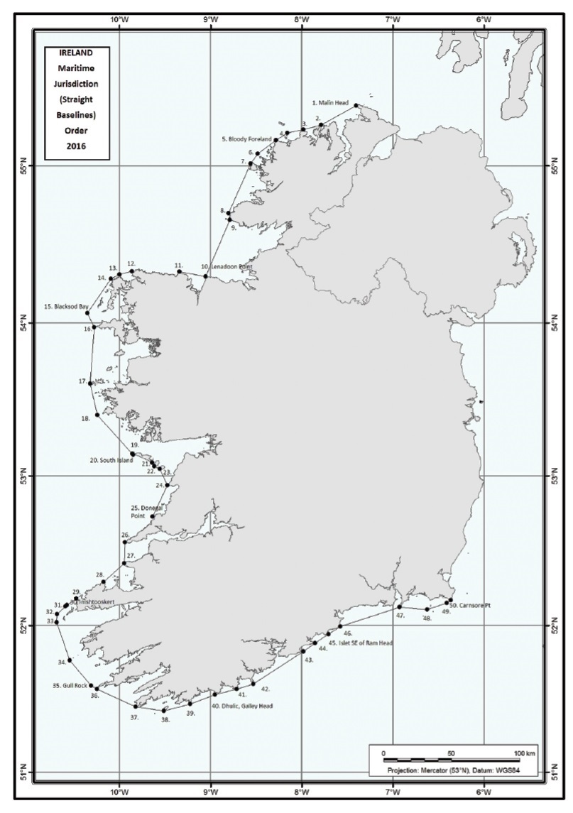
3. Straight lines connecting in succession the following points, defined by co-ordinates of latitude and longitude on the World Geodetic System 1984 datum (WGS 1984), are prescribed as straight baselines:
|
| |
(a) the points specified at reference numbers 1 to 8 of Part A of the Schedule;
|
| |
(b) the points specified at reference numbers 9 to 11 of Part B of the Schedule;
|
| |
(c) the points specified at reference numbers 12 to 20 of Part C of the Schedule;
|
| |
(d) the points specified at reference numbers 21 to 25 of Part D of the Schedule;
|
| |
(e) the points specified at reference numbers 26 to 28 of Part E of the Schedule;
|
| |
(f) the points specified at reference numbers 29 to 50 of Part F of the Schedule.
|
| |
4. The
Maritime Jurisdiction Act 1959
(Straight Baselines) Order 1959 (
S.I. No. 173 of 1959
) is revoked.
|
| |
SCHEDULE
|
| | |
Reference No.
|
Latitude
|
Longitude
|
Description
|
|
Part A
|
|
1
|
55° 22 32.87293" N
|
7° 24 09.48168" W
|
Scart Rocks, Malin Head
|
|
2
|
55° 15 26.04254" N
|
7° 47 14.42085" W
|
Melmore Head
|
|
3
|
55° 13 40.78997" N
|
7° 59 01.05940" W
|
Horn Head
|
|
4
|
55° 12 24.12915" N
|
8° 09 37.21957" W
|
Inishbeg
|
|
5
|
55° 09 35.96316" N
|
8° 17 01.89121" W
|
Bloody Foreland
|
|
6
|
55° 04 32.10846" N
|
8° 28 52.19132" W
|
Stag Rocks
|
|
7
|
55° 00 54.63951" N
|
8° 33 42.21630" W
|
Rinrawros Point, Aran Island
|
|
8
|
54° 41 57.38032" N
|
8° 48 25.53870" W
|
Malinmore Head
|
|
Part B
|
|
9
|
54° 39 35.12589" N
|
8° 47 19.10427" W
|
Malinbeg Bay, West Entrance
|
|
10
|
54° 17 41.73725" N
|
9° 03 29.60920" W
|
Lenadoon Point
|
|
11
|
54° 19 39.88447" N
|
9° 20 44.99838" W
|
Downpatrick Head
|
|
Part C
|
|
12
|
54° 19 49.50515" N
|
9° 51 55.26154" W
|
Kid Island, Broadhaven
|
|
13
|
54° 18 39.55771" N
|
9° 59 55.29010" W
|
Erris Head
|
|
14
|
54° 17 04.53378" N
|
10° 05 30.12885" W
|
Eagle Island
|
|
15
|
54° 03 38.17630" N
|
10° 21 00.96420" W
|
Blacksod Bay (rock SW of Black Rock)
|
|
16
|
53° 58 19.82759" N
|
10° 16 25.13030" W
|
Carrickakin, Achill Island
|
|
17
|
53° 36 11.87952" N
|
10° 18 52.11944" W
|
Kimmeen Rocks, Inishark
|
|
18
|
53° 24 01.03246" N
|
10° 14 25.06583" W
|
Slyne Head
|
|
19
|
53° 08 45.34880" N
|
9° 51 31.37033" W
|
Eeragh Island, Aran Islands
|
|
20
|
53° 08 26.54765" N
|
9° 50 59.44841" W
|
South Island, Aran Islands
|
|
Part D
|
|
21
|
53° 05 18.44451" N
|
9° 38 25.42724" W
|
SE corner Inishmore, Aran Islands
|
|
22
|
53° 03 56.50713" N
|
9° 37 01.66646" W
|
Inishmaan, Aran Islands
|
|
23
|
53° 02 51.97453" N
|
9° 33 16.66174" W
|
Inisheer, Aran Islands
|
|
24
|
52° 56 20.82657" N
|
9° 28 34.97449" W
|
Cregga More
|
|
25
|
52° 43 43.82360" N
|
9° 38 03.41970" W
|
Donegal Point
|
|
Part E
|
|
26
|
52° 33 32.72760" N
|
9° 56 18.05722" W
|
Loop Head
|
|
27
|
52° 25 12.69702" N
|
9° 56 42.01840" W
|
Kerry Head
|
|
28
|
52° 17 29.37530" N
|
10° 10 34.66357" W
|
Deelick Point
|
|
Part F
|
|
29
|
52° 10 55.20606" N
|
10° 28 17.22205" W
|
Sybil Point
|
|
30
|
52° 08 15.36584" N
|
10° 34 25.66524" W
|
Inishtooskert, Blasket Islands
|
|
31
|
52° 07 30.35819" N
|
10° 35 45.37947" W
|
Carrigduff, Blasket Islands
|
|
32
|
52° 04 29.84284" N
|
10° 40 45.80315" W
|
Tearaght Rocks West, Inistearaght
|
|
33
|
52° 01 26.84347" N
|
10° 41 26.28472" W
|
Great Foze Rocks
|
|
34
|
51° 45 53.26444" N
|
10° 32 49.16890" W
|
Washerwoman Rock, Great Skellig
|
|
35
|
51° 35 31.66824" N
|
10° 18 28.34177" W
|
Gull Rock, Dursey Island
|
|
36
|
51° 34 12.52557" N
|
10° 14 53.40665" W
|
The Calf, Dursey Island
|
|
37
|
51° 26 56.91703" N
|
9° 49 16.50803" W
|
Mizen Head
|
|
38
|
51° 25 12.45597" N
|
9° 30 50.31146" W
|
Bream Point, Cape Clear
|
|
39
|
51° 27 59.40209" N
|
9° 13 27.99594" W
|
Strologue, Toe Head — Stags
|
|
40
|
51° 31 46.05211" N
|
8° 57 08.79434" W
|
Dhulic, Galley Head
|
|
41
|
51° 34 09.50390" N
|
8° 42 49.00104" W
|
Seven Heads
|
|
42
|
51° 36 14.30752" N
|
8° 32 04.12550" W
|
Old Head of Kinsale
|
|
43
|
51° 49 28.32329" N
|
7° 59 01.82870" W
|
Ballycotton Island
|
|
44
|
51° 52 51.33027" N
|
7° 51 15.64324" W
|
Knockadoon Head, Capel Island
|
|
45
|
51° 56 30.43116" N
|
7° 42 29.04668" W
|
Islet SE of Ram Head
|
|
46
|
51° 59 41.77191" N
|
7° 34 38.73414" W
|
The Rogue, Mine Head
|
|
47
|
52° 07 21.90213" N
|
6° 55 48.89945" W
|
Hook Head
|
|
48
|
52° 06 31.42349" N
|
6° 37 23.30526" W
|
South end of Great Saltee Island
|
|
49
|
52° 09 17.21990" N
|
6° 24 48.79233" W
|
Black Rock, Carnsore
|
|
50
|
52° 10 20.74906" N
|
6° 21 51.75365" W
|
Carnsore Point
|
|
| |

|
| |
GIVEN under the Official Seal of the Government,
|
| |
13 January 2016.
|
| |
ENDA KENNY,
|
| |
Taoiseach.
|
| |
EXPLANATORY NOTE
|
| |
(This note is not part of the Instrument and does not purport to be a legal interpretation.)
|
| |
The Order prescribes straight baselines for the purposes of the Sea Fisheries and Maritime Jurisdiction Act 2006. A map showing the prescribed straight baselines for illustrative purposes is annexed.
|
| |
|
| |
|