11/02/1933: Fishery 125 No. 3 Or Waterford District
DEPARTMENT OF LANDS AND FISHERIES FISHERIES ACTS, 1842 TO 1925 ____________________________ Definition No. D. 125No. 3 or Waterford District | ||
MOUTH OF THE RIVER MAHON | ||
MOUTH OF THE RIVERS COLLIGAN AND BRICKEY | ||
I, PATRICK J. RUTTLEDGE, Acting Minister for Lands and Fisheries, by virtue and in exercise of the powers vested in me by the Fisheries Act, 1925 , and of every other power enabling me in this behalf | ||
(1) Do hereby define the mouth of the River Mahon, in the No. 3 or Waterford District, to be a straight line (marked M on the map or plan hereto annexed) drawn from a point (marked O) in the townland of Templeyvrick to a point (marked P) in the townland of Knockmahon, both in the County of Waterford. | ||
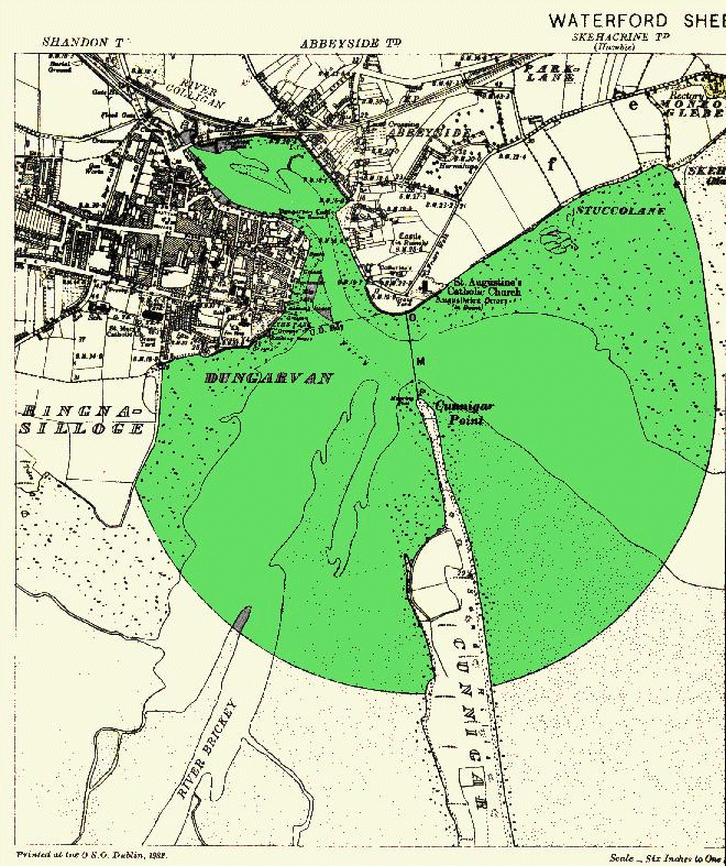
(2) Do hereby define the mouth of the Rivers Colligan and Brickey conjoined, in the No. 3 or Waterford District, to be a straight line (marked M on the map or plan hereto annexed) drawn from a point (marked O) in the townland of Abbeyside to a point (marked P) in the townland of Cunnigar, both in the County of Waterford. | ||
(3) And do hereby define the points of the mouth of each of the said rivers from which distances are to be measured under the Fisheries Acts to be high water mark at each end of the lines M, which points are marked O and P upon the maps or plans hereto annexed, on which said maps or plans are also coloured blue the distances of half a mile within which nets are prohibited by the Fisheries (Ireland) Act, 1842 (5 and 6 Vic., c. 106), Sec. 27, and the Fisheries (Ireland) Act, 1850 (13 and 14 Vic., c. 88), Sec. 44 (vide Note). | ||
(4) And do hereby further define the boundary seaward of the estuary of the said River Mahon to be an arc of a circle marked E on the map or plan hereto annexed having its centre at a point 50 yards true West of the point O and a radius of 150 yards. | ||
(5) And do hereby further define the boundary seaward of the estuary of the said Rivers Colligan and Brickey conjoined to be a straight line drawn in a true South-westerly direction from the outer end of the pier at Ballynacourty. | ||
Given under my Seal of Office this 11th day of February, One Thousand Nine Hundred and Thirty-three. | ||
(Signed), PATRICK J. RUTTLEDGE, | ||
Acting Minister for Lands and Fisheries | ||
|
WATERFORD | ||
| ||
Map or Plan referred to in Definition No. 125 showing the Mouth of the Rivers Colligan and Brickey conjoined in the No. 3 or Waterford District | ||
Reference to colour :- The space within which the use of nets is prohibited (Acts 5 & 6 Vic. C. 106, S. 27 and 13 & 14 Vict. C. 88, S. 44) is coloured blue. | ||
| ||
Map or Plan referred to in Definition No. 125 showing the Mouth and Estuary of the River Mahon in the No. 3 or Waterford District. | ||
Reference to colour :- The space within which the use of nets is prohibited (Acts 5 & 6 Vict. C. 106. S. 27 and 13 & 14 Vict. C. 88, S. 44) is coloured blue. |